Walnut Creek
-
RunWalnut Creek
-
ClassII-III
-
Put InCR 32
-
Take OutCR 264 at Lake Mitchell
-
Length (mi)4.1
-
Gradient (fpm)25, 40, 30, 20
-
Watershed (mi2)42
-
Primary Gage
- None Visual*
-
Indicator Gage
- Hatchet below Rockford ~600 cfs, 800-1100 good
Description
Walnut Creek is a fun little creek that falls into Lake Mitchell near Clanton. It maintains its scenic narrow streambed throughout the four mile stretch from CR 32 to the lake, and the pools are for the most part short. This creek has granite rock jumbles, a far cry from the sandstone and limestone in the north part of the state. This run is uniformly I and II except for three rapids, two of which are certainly class III's at decent water levels. A friendly local canoeist told us about 'the falls' and 'the mill falls'. The last and hardest rapid is just past a low water metal bridge (use caution here). There is not much wood as of early 2008, just two places fairly close to the put in on CR32 where trees have fallen across the creek. This is a great run if you are looking for II and a dash of III, or just need something to run in this part of the state.
You can also extend the run by 3.8 miles by putting in one bridge further up on Mt. Springs Rd. There is less gradient but it is pretty, class 1+ , and moves along at ~1" above the top of the river left concrete support pads on the CR32 (good level). It does work your limbo skills as it has several trees across it, some of which require a carry at this waterlevel. (upper stretch description thanks to JD). Others have described the upper section as punishment with strainers and little gradient.
Access can be an issue at the bottom of the run. To get to CR264 from the lake, you may have to cross private property along the lake. Permission should be sought before doing so. A very gracious landowner, David Miller (205-755-0799), has granted access across his property to some boaters. He lives on river/lake left, second last house on the creek's slough/lake-backwater, off of takeout road 264. Paddling to the public boat ramp on the lake is not recommended unless you relish the workout.
* 4" below the top of the river left concrete support pads on the CR32 put-in bridge is about minimum.
Details
-
ClassII-III
-
Gradient (fpm)25, 40, 30, 20
-
Length (mi)4.1
-
Watershed Size (mi2)42
-
Put InCR 32
-
Take OutCR 264 at Lake Mitchell
-
ShuttleCR32/ CR264
-
Water Quality
 (
2 chickens | 1 = Good, 3 = Gross)
(
2 chickens | 1 = Good, 3 = Gross)
-
Primary Gage
- None Visual*
-
Indicator Gage
- Hatchet below Rockford ~600 cfs, 800-1100 good
-
Precip. Gage
Map
Video
Photos
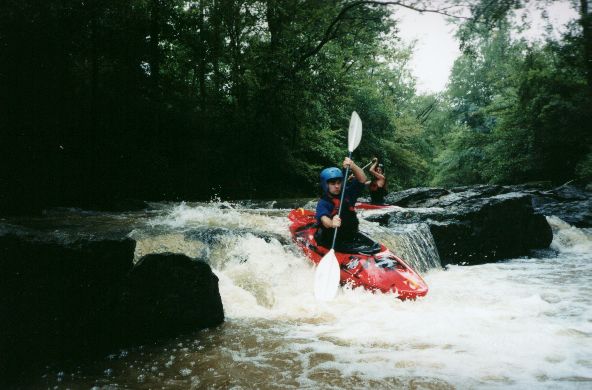
Jason Ory at 'the falls'.
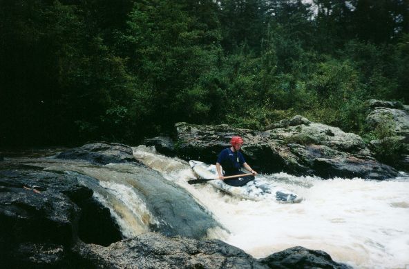
Mark D' at what may be 'the mill falls'.
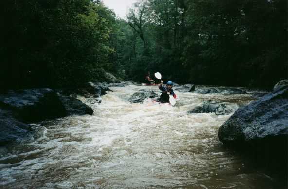
Neat, narrow, granite boulder garden. We could have used more water.
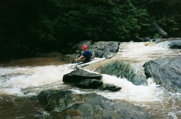
The last drop of the best rapid towards the lake.
Trip Reports
Labor Day Whitewater: Two W's
September 2, Long Ago
Written by Mark D'Agostino
Gary and I had talked about going Saturday, but the rain was just getting its act together. The best water was to the south on Sunday, so we decided to go. Jason joined us in Cullman on the way down.
We knew that Hatchet was on its way up, so we were fairly confident there was some water south of Birmingham, which we knew had lots of water but not many runs. Our first objective was Walnut Creek, which flows out of Clanton into Lake Mitchell not far from Highway 65. I had seen it on the topo and knew it had decent 30-40 feet/mile gradient over 4.1 miles. I had been told it had some drops but knew no one who had run it. We got near Walnut without any problem but made a few wrong turns on some unmarked dirt county roads. Finally we found the put-in and proceeded to the take-out area. We had to take-out at the lake so we eventually just decided to park near some empty lake houses and sprint to the truck when we took out. Back at the put-in we ran into a local who canoes the first half of the run and owns a house right next to our take-out vehicle. His description of the run sounded promising.
We found the level to be minimal but OK. The creek remains narrow and is bounded by almost all granite, which is quite a change from north Alabama creeks. I think this was the only run I've done in Alabama that had granite boulder gardens. The water moved along nicely and was class I and II except for three rapids. The local guy called the first two III's 'the falls' and 'mill falls'. After the mill falls we thought we might have hit the lake but instead went under a couple river wide logs and a low water bridge. Just after that was the best rapid of the run, a three part ledge. We really liked Walnut and with a bit more water it would be worth another run. Club members with a bent towards the II (III) way of paddling will really like this run. It would be a fun run for someone who has not run creeks much or simply does not want a dose of fear with their paddling.
At the take-out we loaded up our gear and ourselves into and onto Jason's Jeep. We decided since we'd driven this far we'd have to make two runs. So we headed to Weoka Creek on the other side of the Coosa River. We put on and quickly discovered the flow was REALLY low. Gary had declared, "We can always drag our boats for 1.9 miles". Well, we did not have to get out of our boats but we did some dragging. There was little in the way of whitewater until we got to the old Weoka Mills. Here the creeks drops about 15' before it goes over or under the old dam. This rapid would edge up to class IV with possible big holes at high water. Unless you live in the area, Weoka is only probably worth running in combination with something else in the area.
Jason has just started to paddle whitewater this summer but he did very well, having no problems except for the odd spin cycle by shallow rocks. It is fun to see somebody in the initial super high enthusiasm stage that that gets you on the water every week. This year has been good for that with all the rain. Reminds me a bit of 1994.