Big Scirum Creek
-
RunBig Scirum Creek
-
ClassIV
-
Put InJoy Rd (CR 37)
-
Take OutHwy 160 (On Locust)
-
Length (mi)1.0
-
Gradient (fpm)200
-
Watershed (mi2)4.4
-
Primary Gage
- Put in Culvert ~3'+ & visual (see text)
-
Indicator Gage
- Blue Springs 200? - recent rain, rising!
Description
If overall run quality (Q) can be expressed by the following:
Q = Grins / Hardships
where for Big Scirum,
Grins = Many
Hardships = Nearly None
Therefore, Big Scirum's Q = a large number
In other words, Big Scirum is one of the best runs around!
Big Scirum Creek runs into the Locust Fork just above Scirum Bluff, less than one mile upstream of the Highway 160 takeout. Like Graves, its sister creek upstream, it has a couple of big drops. Unlike Graves, you don't have to paddle a lot of flatwater to get to the takeout and Scirum packs a higher adrenaline load. This is a sweet little class IV run that is rarely paddled for one reason or another, mainly the fact that it is hard to catch with enough water. As word spreads however, it is becoming somewhat popular on big rain days.
Access at the put-in is sketchy at best, with several houses along the banks, so please be considerate of the landowners and put in across the road, upstream of the tunnel. After you run the tunnel (actually the biggest metal culvert I've ever seen), your first drop is a six foot dam literally in someone's backyard. It's deep enough, so bang on through here without disturbing the owners. Ensure that you that you have sufficient kinetic energy to clear the hole, it has claimed paddlers and is reluctant to give up an unoccupied boat. The next bend puts you into a small, sheer-walled hallway barely two boat-lengths wide, at the end of which sits the first big drop, a 5 foot boof off an old dam onto a ~30 foot slide. Big, visually intimidating from the top boat scout, not too difficult, and always worth a major hoot at the bottom. This drop is also watched over by a house, so don't get out to scout unless absolutely necessary! You will be trespassing the moment you step out of your boat! A boat-scout should do fine. Take your boof just right of center, with a slight left angle, then start driving generally left to avoid the slightly undercut sharp right wall. If you blink you might miss the whole experience, because you will be smoking at the bottom. After a pool, the creek is mostly class III for the next 1/2 mile, with a couple of class III+ drops. Worthy of mention are a route on river left that demands a boof over a rock with pitons a roll of the dice. A slide along the right wall has a sticky hole at the bottom where those short on momentum may have some rodeo moments. A blind slide around a right bend with a cliff on the left might merit a scout. Catch an eddy on the right across from the left bluff since the next drop is the falls.
The slide into the falls is just after the first big bluff on the left. The falls are on an angle and have some extended points, but the pool is deep. Scout right. It's a ~12' broken ledge with a long sloping slide lead-in that curves right then left. The best line is off the first rock on the left that juts out past the creases and folds to the right. Unfortunately it is not completely straightforward to get to this point, so make the best of it if you have to and hit the falls square, try to get as left as possible on the appraoch. The next drop is pretty ugly at lower levels, so pay attention to the water bubbling out from under the right cliff before you make your decision, and run left if there is enough water. The easy walk is also on the left. From there, it is 1/4 mile at most of manky class IV depending on level. You may want to scout at least the first rapid in this stretch to verify that the log removal efforts have not been undone by Mother Nature. Watch the last drop into the Locust, there is a tree root complex on the right, so it is best run over the middle rock if water allows. If the Locust is running around 10', this last rapid will be completely submerged, and the key move of the run will be avoiding the huge whirlpool at scirum bluff on the Locust.
A word of warning: This run has possible access problems. If it looks like private property, it probably is. Posted signs abound. Do us all a favor and don't spend much time at the put-in. The locals approached us and were quite nice, but a little unsure as to why we were there, "cause they's nothin' but waterfalls and pools down there. You'll be walking more than floatin" Needless to say, that made us all smile! I believe the posted signs are to keep the summertime beer drinking crowds out, but let's be nice and not spoil this very sweet run by being anything less than highly courteous and circumspect. The new owners of the house at the put in on river left are very nice, so lets be nice back.
A gage has been painted in late 2006 on the river left downstream edge of the put-in culvert. 1' is wet rocks and boat abuse. 2' is low but doable, 2.75' is OK but a bit low near the Locust, 3.5' is nice, 4.5' is now the high side of medium and thinsg start to clean up on the mank near the Locust. 5' is about where high starts. Scirum has been run at very high levels, but I'm not recommending repeating that. The backup method is getting an eyeball on the river right pyramid rock just downstream of the culvert as shown in the pictures. If is is almost covered, then the run is high. If it's top is about 3-4" above the waterline, you have a very nice level.
The stream was cleared out in early 2007 (you are welcome). The two trees that have fallen since can be either ducked or avoided to the right.
-Shane Hulsey & Mark D'
Details
-
ClassIV
-
Gradient (fpm)200
-
Length (mi)1.0
-
Watershed Size (mi2)4.4
-
Put InJoy Rd (CR 37)
-
Take OutHwy 160 (On Locust)
-
ShuttleJoy / Nectar / Hwy 160
-
Water Quality
 (
2 chickens | 1 = Good, 3 = Gross)
(
2 chickens | 1 = Good, 3 = Gross)
-
Primary Gage
- Put in Culvert ~3'+ & visual (see text)
-
Indicator Gage
- Blue Springs 200? - recent rain, rising!
-
Precip. Gage
Map
Video
Photos
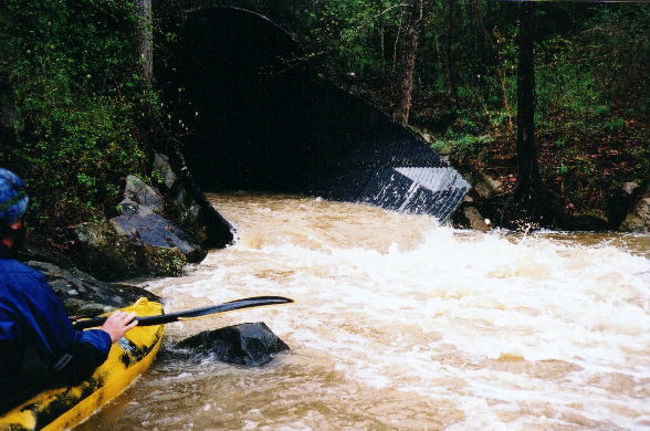
The downstream end of the put-in culvert. You can perhaps judge water level by the rock under Shane's paddle blade. This was a good level.
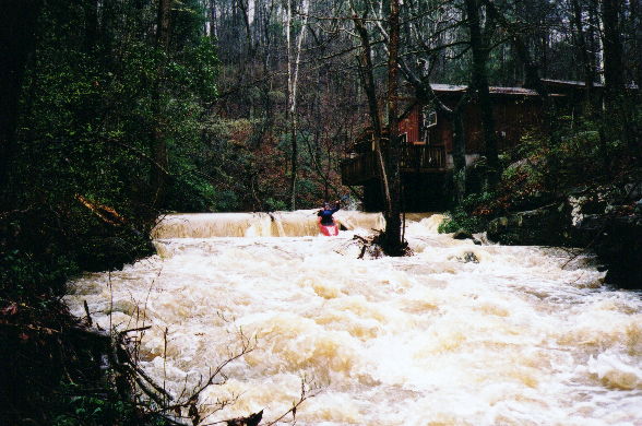
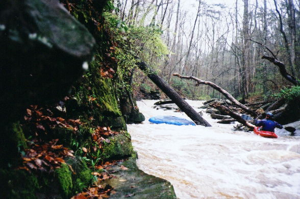
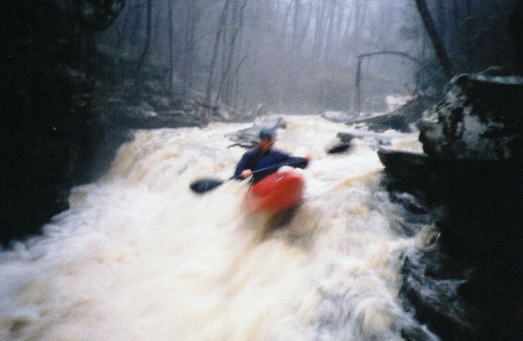
Greg Lawrence on the first dam drop
Shane Hulsey towards the bottom of the big slide. From the top, you can only see the bottom of the slide. Very cool. Don't get stuffed (...)
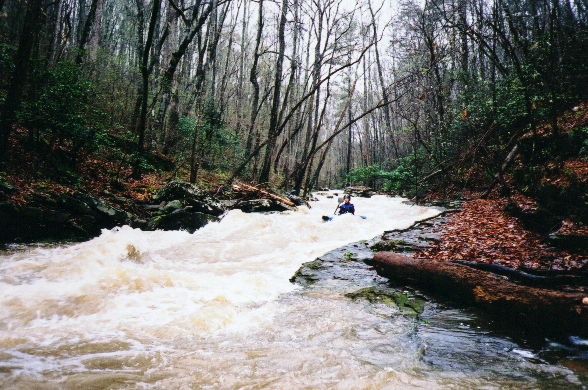
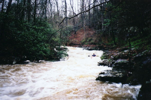
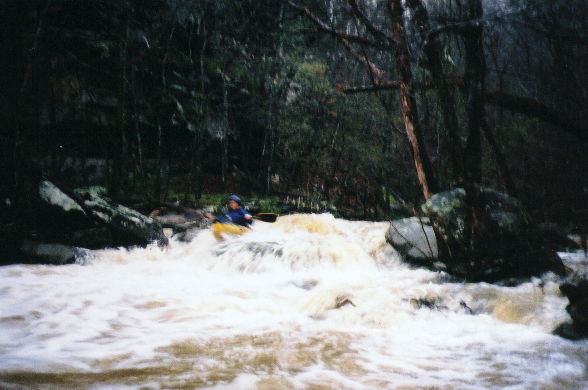
Bert Harris in a typical stretch between the slide and the falls.
Greg looks on as Bert completes his rodeo moves at a sticky hole upstream of the diagonal log
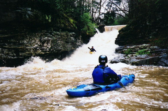
Greg runs the slide above the falls. We are in the last eddy, and I ferried across to scout. Greg realized this was the last eddy a bit too late.
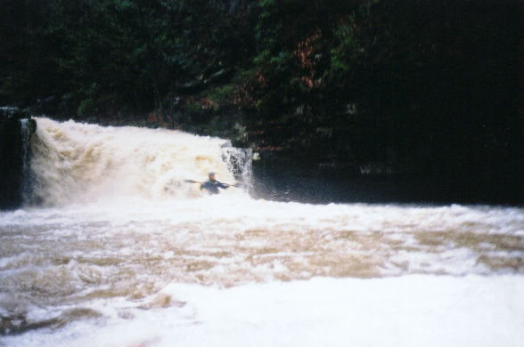
Shane on line at the falls.
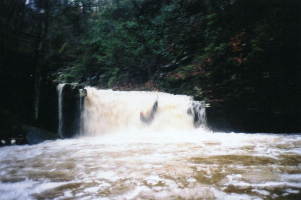
Mark D' with R-rated results. I was back paddling just above the drop, trying to hit the line to my left. "What am I doing?" I thought to my (...)
Gerg runs left to avoid the undercut wall below the falls.
Shane on the last drop into the Locust. If you paddle by Big Scirum and you see this much water, hit it.