Chinquapin Creek
-
RunChinquapin Creek
-
ClassV
-
Put InLower Canyon Rim Road
-
Take OutLittle River Canyon
-
Length (mi)0.75
-
Gradient (fpm)350' (0.75 mi.)
-
Watershed (mi2)4.9
-
Primary Gage
- Put-in Bridge 3 in.?
-
Indicator Gage
- Little River near Blue Pond 4500 cfs?
Description
Editor's intro: Chinquapin is the only 'significant' tributary flowing into Little River Canyon between Bear and Johnnies Creeks. It is steep. 350 feet in about 3/4 mile. It's a neat, but not easy, hike. A series of 20' waterfalls are separated by 30' to 50' slides. It requires a pretty significant rain to get it going. If you run it, you don't need a guide, but you may yet find yourself in need.
From B. Thornton: It is extremely steep non-stop action. There are several long slides and a couple of big drops in the 20' range, also some severe boulder clogs. The most interesting feature is a 20' waterfall that falls into a dead end pool. The outflow runs down a steep pile of boulders behind the falls. It was ELF the day we ran it, but I'd guess that it might be decent at levels between 1.5' and 2.5' on the LRC 35 bridge gauge. According to my estimation it drops 330' in six tenths of a mile giving it an gradient of 553 fpm. The biggest danger would be putting on it with too much water. It wouldn't take much to turn it into a half mile long log flume right down into the canyon.
Brad Hinds: I am pretty sure we did the first descent of Chinquapin Creek about six years ago (1995?). We ran everything but one drop were it sieved out after the second drop which was a bouncy slide. It is actually a good run at high water flow, the only problem is, there are better choices when it runs high.
More thoughts from Milt Aitken:
The first drop is in "Tales of the Paddlesnake". It is the easiest, by far.
It has 7 major drops, 3 of which are going to be really hard, maybe unrunnable with real water in it. We had 4 people, but the kayaks pitoned & hit the shelf below the first drop & bailed. The two canoes ran it OK, but 23 feet is a long way to fall in a 14 foot canoe. It hurt when I hit.
Since the buttboaters bailed, we had to hike out. The Teddy Bear was running with decent water by the time we hiked out & reset shuttle. Chinquapin had dropped to nothing by then.
There's a painted guage on the bridge. We tried it at 3". I think 6" would let you run the first falls gracefully, but the third drop concerns me at that level.
I'd try it again, but only if we have enough people to set ropes at most of the drops. It will be very unforgiving. Once you're past the third drop, there won't be any hiking out.
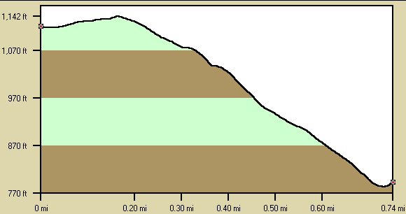
Below is a profile of the creek gradient. These data are not as accurate as the gradient field above but do give a graphical feel for how the gradient is distributed.
Details
-
ClassV
-
Gradient (fpm)350' (0.75 mi.)
-
Length (mi)0.75
-
Watershed Size (mi2)4.9
-
Put InLower Canyon Rim Road
-
Take OutLittle River Canyon
-
ShuttleCR 275
-
Water Quality
 (
2 chickens | 1 = Good, 3 = Gross)
(
2 chickens | 1 = Good, 3 = Gross)
-
Primary Gage
- Put-in Bridge 3 in.?
-
Indicator Gage
- Little River near Blue Pond 4500 cfs?
-
Precip. Gage
Map
Video
Photos
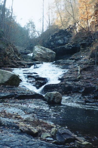
One of the many slides that separate the waterfalls. Note the big rock that has fallen in to provide the extra undercut angle. These are pictures f (...)
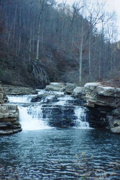
A comparatively simple drop over halfway to LRC. These are pictures from a scouting hike in 1997.