Big Wills Creek
-
RunBig Wills Creek
-
ClassI-II
-
Put InMultiple (see text)
-
Take OutMultiple (see text)
-
Length (mi)9.5 (upper run)
-
Gradient (fpm)9'/mile (upper run)
-
Watershed (mi2)47.6
-
Primary Gage
- Big Wills near Reece City ~250 cfs
-
Indicator Gage
none
Description
There are several sections of Big Wills creek that can be run. Here are two descriptions starting with an upper run. Lebanon is on the topos but does not make it into the Gazeteer. It is just east of Horton. There are a couple old mill sites along the way (all upstream of Lebanon?) which might provide the drops. Many available access roads are available.
Nick Parker writes:
Big Wills Creek (just west of Fort Payne, in Big Wills Valley) ran adjacent to my family's farm in Lebanon, AL. My brother and I (and a couple of friends) took Grummans down it, in 1972(?). I do remember it being a lot of fun at the time (the only paddling we had done prior to that was on flat water).
Our put-in was on Airport Road in Fort Payne, near the intersection of I-59 and Hwy35. Our take-out was on CR293, near Lebanon.
We didn't take any pictures. I can't say I remember exactly what the rapids were like, but they were probably class I/II, interspersed between stretches of flat water. It's a pretty big creek, there were islands, lots of wildlife, etc. The biggest rapid I remember was a stepped rapid (which flipped one of the canoes). There was at least one low dam, near Lebanon. I have no idea what the creek is like farther north or south.
Josh Tidwell:
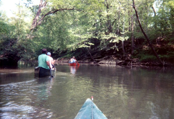
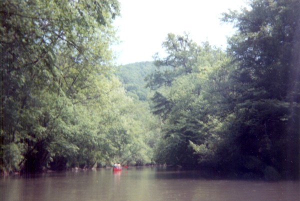
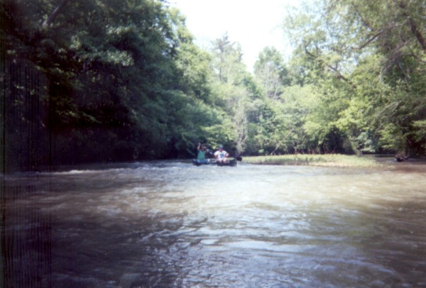
I have paddled Big Wills from Stephens Gap Rd. (pg.26, D4) to Lake Gadsden. The stream flows through a valley with farmland on river right, and Big Ridge on river left. The water quality would be a 2 at best, because of pasture run-off during rain, but is surprisingly clear during dry times. The bottom ranges from rocky, to gravel, to mud. There are many bluffs coming into the creek. Wildlife is abundant, I have seen deer, turkey, raccoon, beaver, nutria, waterfowl, and even a river otter, which tried to jump into my boat. The fishing is good for bass, panfish, and catfish.
The creek has many sharp turns, and fast current with decent levels, class I and II shoals abound. There are strainers everywhere, but there is almost always a clear route. There are several areas in this section of interest, or concern, for paddlers. Just below Hwy 211 (pg.26, E3) there are several low rock ledges that have standing waves, suitable for surfing at moderate levels. Just below Hwy 431 (pg.26, F2) there is a 4ft dam that is broken on the far left. This break is runnable, and may be class II+ or III- with large standing waves. Be careful here, during high water a portage is very hard, if not impossible. Everywhere other than the break, the water drops vertically 4', creating an ugly hydraulic. During low water you can portage directly over the dam. The other area of concern is another dam. This was the pumping station for the now defunct Gulf States Steel. It is directly below the first bridge, after you cross under I-59. This is a must portage, take out above the bridge and put back in below the dam. The creek is floatable year round,with only minimal scraping during dry times.
The creek flows through lots of history. It is written that Sequoyah composed part of the Cherokee alphabet in Duck Springs. The first hydroelectric power plant in the world was built on Big Wills. Alabama Power was founded there. The marker stands on Hwy 431 where it crosses the creek. The Kyuka bottled water company is located on its banks. The water comes from a subterranean river, not the creek.:-)
Details
-
ClassI-II
-
Gradient (fpm)9'/mile (upper run)
-
Length (mi)9.5 (upper run)
-
Watershed Size (mi2)47.6
-
Put InMultiple (see text)
-
Take OutMultiple (see text)
-
ShuttleAirport Road / Hwy35 / Briarwood Ave / 51(Lebanon Road) / 52
-
Water Quality
 (
2 chickens | 1 = Good, 3 = Gross)
(
2 chickens | 1 = Good, 3 = Gross)
-
Primary Gage
- Big Wills near Reece City ~250 cfs
-
Indicator Gage
-
Precip. Gage
Map
Video
Photos
(Josh Tidwell Photo)
(Josh Tidwell Photo)
(Josh Tidwell Photo)
Trip Reports
Big Wills Creek
April 20, 2002
Written by Jerry Jones
Myself and a party consisting of my wife, son (6 yrs old as of 4/12/02) and two of my nieces (ages 14 & 16 and first time paddlers) paddled Big Wills on 4/20/02 from Stephen's Gap Rd to US Hwy 431.
The put in was a very easy 50 yard portage with a nice sandy/muddy launch area safely out of the fairly slow current. There were three fairly large log jams within the first 2 miles one which requires about a 200 yd portage (around a barbed wire fence on a very small ledge the first 15 yds or so). The most disappointing part of the trip comes early. The best rapid on the creek (class I/II narrow slide approx. 6 ft @ a 45 degree slant with standing waves at the bottom) is completely blocked by several log jams the largest being a 3ft in diameter fallen oak tree and involves the above mentioned difficult portage. There are a few widely spaced shoals and two more easy to cross (which we did even with a six year old) or portage log jams. It took us about 4 hours to complete the upper section of the run which is approx. 9 miles. This could have been done in 3.5 hr. with constant strong paddling.
The second section starts at Bruton Bridge Rd. I would recommend this section to anyone. Three very easy to portage or cross log jams are the only obstruction in a 3 hour approx. 6 mile float. This section has less flatwater between the shoals, there is however no serious whitewater. Only one that approaches class I (at 507.8 ft on the Henry Dam via 1-800-LAKES-11). Wild life was abundant as were wading cows. We saw several Wood Ducks, one hen with ducklings, which feigned injury to bait us away from her babies. One trickling waterfall could be spotted on river left falling from one of many high bluffs in this section. The take out is between the South bound bridge and the railroad bridge on river right. Take out is easy but requires either a vehicle other than a passenger car (due to ground clearance), or a 75 yard portage through some mud. This section is a great float for any one of any level of experience looking for a fairly short, fun, relaxing run with excellent scenery.