Mill Creek, below Smith Lake
Description
Mill Creek is a nice pool/drop class II-III run that flows into the Sipsey Fork below Smith Dam. It's probably one of the best runs west of I-65, which is not saying a great deal since gradient can be hard to come by there. It certainly beats anything north of Smith Lake for whitewater anyway. It would be a nice step up from the Locust in difficulty along with East Fork Flint Creek north of Cullman, though Mill is longer and is missing the bigger drop found on EFFC. Mill is a micro creek and needs some pretty good rainfall to get it running. There is no visual gauge yet but you need good bank flow at the takeout.
Mike Smith and others had walked part of Mill during the summer of 2008, and Alf Van Hoose is once again loose on the topo maps of Alabama. Mike could not be rousted for the run, but a few of us took the plunge on February 5, 2010. I sort of doubt we got a first descent, but who knows. In fact, we left a fair bit of meat on these bones if you want to check it out. I like any new run with a good dose of suffering (pain is a great memory aid), but many don't have my masochistic tendencies. You can benefit from our mistakes as well as good fortune. Two put in options exist. Don't take the one we did. We used Little Mill. It was a tree infested scrape-fest. Instead, use Mill at Burrows Crossing Road. The parking is not great, but there is a lot more flow than on Little Mill and the trees cannot be worse. You can also consider running the last 0.7 miles or so below CR43 to the Sipsey, there is another 20' of gradient and a rapid or two could be in there.
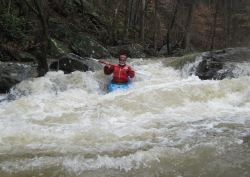
Since I've not seen the upper 2.6 miles to the confluence with Little Mill, we can only speculate on what wonders are found there. It's probably a few slides and drops with a number of trees, but you won't know until you go. After Little Mill joins, the volume picks up and the scenery is nice. A number of undercut bluffs and tributary waterfalls liven the float. It's nothing adrenaline depleting, but it is pleasant. There are two "significant" drops. One has a boof on center right or farther left, the key is to not go too far right and hit a pin rock. The second one is further down. It's best line would be left but that is basically blocked by trees. So we went right and and then left, which could be dynamic at high water. Overall, Mill is a good II/III run that is surprisingly wide for such a small looking creek.
Let us know if you run the upper part or below CR43.
Details
-
ClassII-III
-
Gradient (fpm)40, 20, 20, 40, 40, 25, 20 (0.7)
-
Length (mi)6.7
-
Watershed Size (mi2)6.6
-
Put InBurrows Crossing Road
-
Take OutCR43 (Smith Lake Dam Road)
-
ShuttleCR43 / AL69 / Burrows Crossing Road
 (
2 chickens | 1 = Good, 3 = Gross)
(
2 chickens | 1 = Good, 3 = Gross)
Map
Video
Photos