Blackburn Fork of the Warrior River
-
RunBlackburn Fork of the Warrior River
-
ClassIII (IV-V)
-
Put InHouse Rd, Rt. 15 dirt road
-
Take OutRt. 15, Little Warrior
-
Length (mi)4.5
-
Gradient (fpm)60, 20, 20, 20
-
Watershed (mi2)90.2
-
Primary Gage
-
Indicator Gage
- Locust at Cleveland 6' (and/or rising)
- Inland Lake Level Above Full Pool (>784')
Description
From Tim Hudson:
The Blackburn is one the best beginner creekin runs this far south. When the lake fills up & pours over, it runs for days. The water is clear, warm, & clean (as water can be in the dirty south). It starts slow and scenic and goes right by some Histroric Caves. A few little drops, then the river drops out of sight. Eddy out on either side & scout! The portage as I call it, Pall Mall Falls is a sweet rapid, but deserves alot of caution. I think it is like a rapid in the Little River Suicide Section. Best level in my opinion is 3'. It gets pushy above that & scrapy below that level. I have run it from 3.1' to 2.75'. And once again my opinion is solid class 5, not because of the move, but if you mess up you may get dead. The hole river left sieves out, and you must make it right at the bottom. You can portage easy on either side, just respect the land owner, He likes to keep it private, but doesn't mind to see people enjoy the river. The next 200 yards are some fun class 3 rapids, that can compare to rapids on Town creek. So if you think you are ready for more than the Locust Fork, these rapids will let you know. But then it is class 1 scenic flat for about a mile & a half, but not too bad, the higher the water. Just be prepared to float out.
The shuttle is pretty easy. House Rd is the put-in, right off C.R. 15, near Limestone Springs. The take-out is on C.R. 15, park up the hill from the bridge, on the corner of Deavers Town RD & C.R. 15. Parking at the bridge will get you TOWED, so do not do it.
This run features both a legacy visual gauge as well as a new online gauge courtesy of the folks at Streambeam. Once the lake upstream is full and spilling over the dam, 2 feet on the visual gauge is low & scrapy but you can make it down river, and only walk the portage. 4 feet is going to be pretty high & pushy so use your on judgement on that. The gauge is on the river right hand side, under the put-in bridge, hard to see, but walk out on the bridge and look under it. As of 4-2011 in only goes to 3.1 because it broke off, but I will fix it these summer.
The Streambeam gauge is located on the takeout bridge, and appears to correlate well with the visual gauge at the put-in. It can be accessed via the link below to check the level before leaving your house; on this gauge, look for 1.25' as a minumum, 2.25' for good flow, and 3.75' for high flow. The correlation is still being developed, and timestamped visuals of the put-in gauge can be submitted via the Streambeam web site to solidify the relation between the visual and Streambeam gauges.
Details
-
ClassIII (IV-V)
-
Gradient (fpm)60, 20, 20, 20
-
Length (mi)4.5
-
Watershed Size (mi2)90.2
-
Put InHouse Rd, Rt. 15 dirt road
-
Take OutRt. 15, Little Warrior
-
ShuttleCR 15
-
Water Quality
 (
2 chickens | 1 = Good, 3 = Gross)
(
2 chickens | 1 = Good, 3 = Gross)
-
Primary Gage
-
Indicator Gage
- Locust at Cleveland 6' (and/or rising)
- Inland Lake Level Above Full Pool (>784')
-
Precip. Gage
Map
Video
Photos
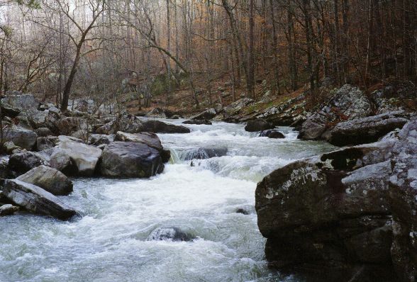
A tree infested drop on the Blackburn Fork. As of 3/2000, this drop was clean. But, this leads into a pretty much unrunnable jumble that must be portaged. (...)
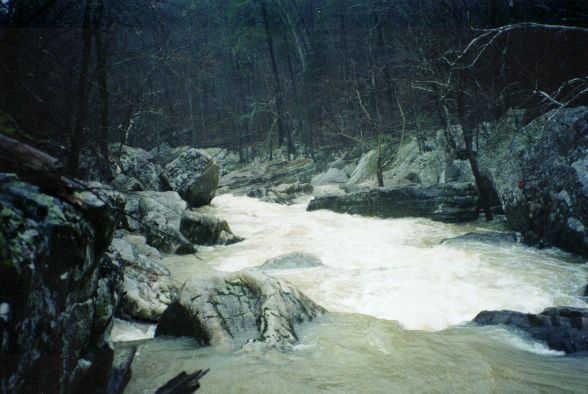
This is a view of the same drop looking downstream at a good water level. The horizon line is...
This little item. It might be runnable through the river right slot but the tree currently residing there prevents that line at this time.
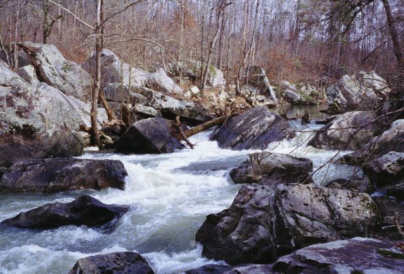
A sampler shot of the only set of rapids on the run, at kind of low water.
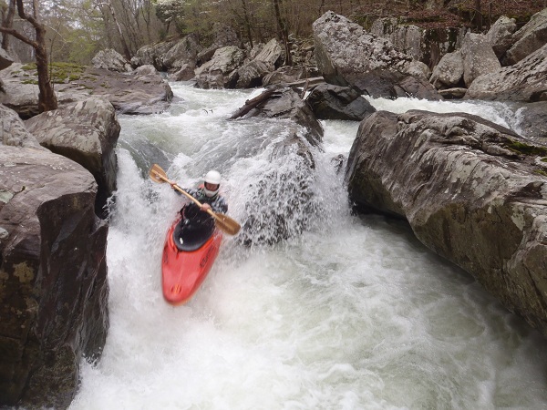
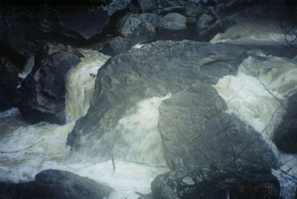
Tim Hudson cleans Pall Mall (photo courtesy Tim Hudson)
Trip Reports
The Quick Workout
February 12, 1993
Written by Charlie Stotts
STATS:
date: Feb 12, 1993 air temp at put-in: approximately 40 degrees F
weather: An overcast morning broke up and gave way to a sunny afternoon.
boaters: Charlie Stotts, John Reynolds, Roy Waldrup and Mike Abernathy
geographics: Southern Sand Mountain 35 miles north of Birmingham \
watershed: Blackbum Fork
class: class III maybe IV (VI)
level: 6.2 feet at the highway 79/Locust Fork gauge
section: The short section upstream from the no-access bridge.
river distance: approximately four miles
physical stimuli: One exhilarating mile of nearly flat water paddling ended at a blockage choked with trees. This point marked the beginning of some real whitewater fun. The portage was over 100 yards through recently cut over timber, tree tops and a boulder strewn, steep gradient. After all of our dues were paid, we enjoyed boofing through what might have been some exciting class III/IV drops (if there had been another foot of water). After 3/4 miles of this rapture, you can imagine our relief when the gradient eased. We pried our white knuckles off our paddles and set about to savor the remaining 2.5 miles of flat water bliss. Upon sighting the no-access bridge, giddiness overcame us in anticipation of the trailless, sawbriar guarded, 30 foot climb to the roadway.
objective: Take in a new creek.
resultant: Overcome with exhaustion.
rewards: After all the equipment was loaded, a full bodied cold carbonated beverage was served. Thanks Mike
diagnosis: The subjects demonstrate the classic symptoms of ‘whitewater denial'. What else would explain promising to be back for an important banquet at 5:00 knowing that a new creek would be full of unknown delays?
prognosis: After a long stay at a good paddling detox center, they should be able to function with limited disability.
prescription: A two week intensive program at the world famous “Institute for the Hydro-logically Imapired”. This, of course, being the one located at Wesser, North Carolina.
conclusions: Life is good when you are a paddler with a forgiving wife.
February 12, 1994
Written by John Reynolds
With water everywhere, but evening time constraints looming, four paddlers put on Blackburn Fork. The Locust Fork was at 6.2 feet and dropping from a reported high of over 11 feet the day before. The first mile or so of Blackburn is flat, followed by the Blockage, a mandatory portage. After the portage is 3/4 mile of Class III creek type water, which then levels off to pastoral Class I gravel bar type water. Some of the area has been logged recently, and storm-felled trees were in the water in a few places. The bluffs contained some shale which is rare in the limestone/sandstone we usually paddle. Every one agreed it was a pretty paddle but the difficulty of the portage and takeout and the extent of the flat water put it on the ‘once every few years' list. Participants: Mike Abernathy, Roy Waldrup, Charlie Stotts and John Reynolds. Directions: Read Locust Fork Gauge at Cleveland, Drive south on US79 to Locust Fork. Turn around and drive back to first right (before bridge). Turn right. First bridge is take out. Drive couple of miles looking for an old low water bridge on side dirt road. Put in at low water bridge.