Socapatoy Creek Cave Run
-
RunSocapatoy Creek
-
ClassII-III+
-
Put InCR 111
-
Take OutHwy 231 on Hatchet Creek
-
Length (mi)4.7 (+1.1 on Hatchet)
-
Gradient (fpm)20, 10, 10, 20, 40 (0.7)
-
Watershed (mi2)45.9
-
Primary Gage
- None Visual
-
Indicator Gage
- Hatchet below Rockford 750 min, 1000 better
Description
(with lots of help from Alex Baird)
Socapatoy is a brief chunk of high quality whitewater that is well worth checking out if you are in the Central Alabama area (Hatchet, Alexander City, Sylacauga). It may be one of the best whitewater runs in Central Alabama. It has a decent watershed, but you need to catch it when Hatchet is running fairly high. Like many other creeks in this area, it's gradient is concentrated in a relatively short section where it drops into another larger creek, in this case Hatchet. The short steep section is referred to as Devil's Canyon. The entire lower section is called the cave run. You could run above this, but it is long and may have relatively few rapids. The CR 111 put-in road is the last road over the creek before it joins Hatchet, and the take-out is on Hatchet at Highway 231. The put-in is a 10 minute ride down a decent dirt road off Hwy 280 that would be real slick just after a rain. It meanders a lot, but is easy to follow since almost all the wrong turns are gated.
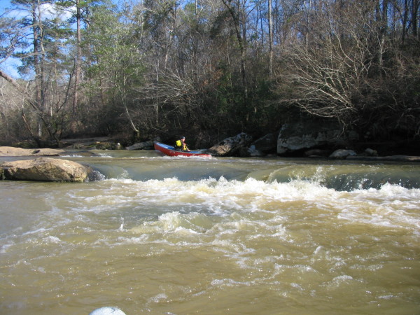
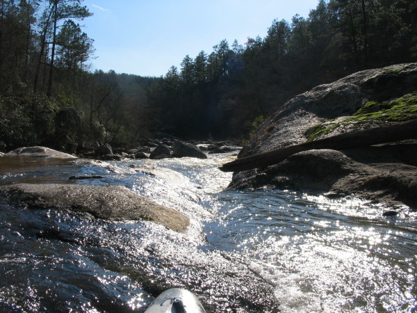
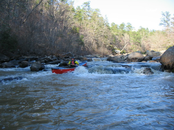
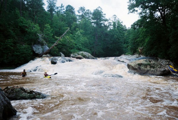
There is a rapid with a fair bit of drop just upstream of the put-in bridge that you might want to look at or carry up to run. It is then pretty flat for the first few miles. The end of the flat is abrupt. The meat of the run is really one big rapid with an impressive view from above. You start out with a class II rapid called Blindside. It shoots you down the creek into a double drop, 3' followed by a 4' waterfall. Then it sends you to the mouth of the biggest rapid on the run. There are two lines you could take. First, you could go down the left of the big boulder onto chicken falls (an 8' waterfall) which leads you to the slide rapid (pictured above), or you could take the line that leads to the frozen rope (on photo page). I think the option we chose was to run far right to left from the eddy just below the big boulder. This was a fast and very fun line (see video). There is a good pool at the bottom. The next hundred yards is a boulder garden with a few 3' drops in it. Finally there is attitude. It is a slushy rapid that will toss you around a little. At runnable water levels, this is a classic whitewater run. The whole Devil's Canyon stretch will be one big class IV with big hole potential at high water.
As of early 2005, what little deadfall there is can be avoided. The required level on Hatchet is somewhat of a guess. Also keep in mind that Hatchet has a long watershed, so it is best to look at recent rainfall in the Socapatoy area. Finally, check out the trip report linked above. It is pretty funny. They put-in farther upstream and at really low water, but the best tales are always born when things go awry. The easiest shuttle is to go north from the take-out on 231, turn right on CR 49 in Hanover, then go south on Hwy 280 to CR 111.
Details
-
ClassII-III+
-
Gradient (fpm)20, 10, 10, 20, 40 (0.7)
-
Length (mi)4.7 (+1.1 on Hatchet)
-
Watershed Size (mi2)45.9
-
Put InCR 111
-
Take OutHwy 231 on Hatchet Creek
-
ShuttleCR111/ Hwy280/ CR49/ Hwy231
-
Water Quality
 (
2 chickens | 1 = Good, 3 = Gross)
(
2 chickens | 1 = Good, 3 = Gross)
-
Primary Gage
- None Visual
-
Indicator Gage
- Hatchet below Rockford 750 min, 1000 better
-
Precip. Gage
Map
Video
Photos
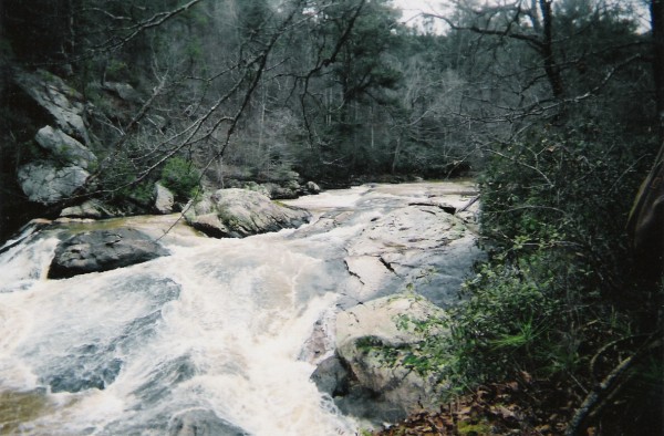
The drops at the top of the biggest rapid. Photo Courtesy Alex Baird
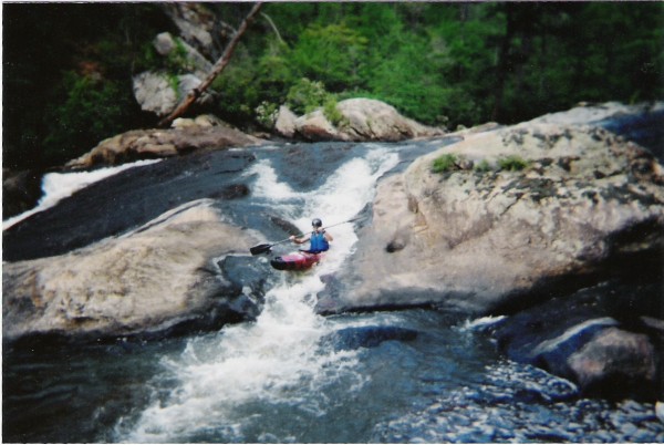
I believe this is frozen rope, the river right line on the big rapid. Photo Courtesy Alex Baird
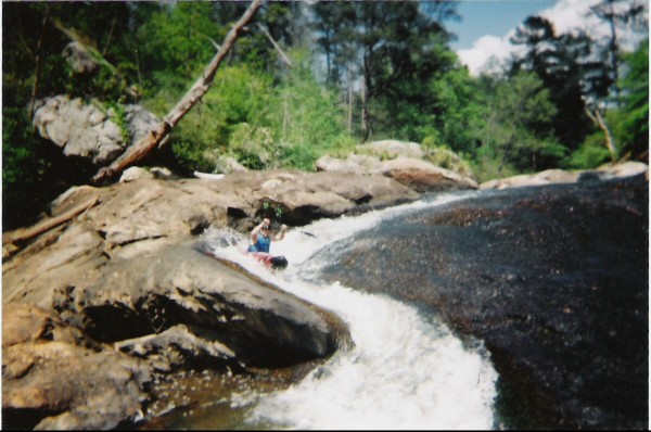
This is the slide at low water on river left. A video of the far left to right line is here. Photos Courtesy Alex Baird
This is a higher perspective on the main drops at a low, but better level. Photo Courtesy Alex Baird
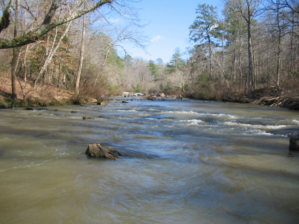
The view upstream from the put-in bridge. If I had more time, I would have looked at it and maybe ran this rapid. It looked to have about a 5' drop in it.
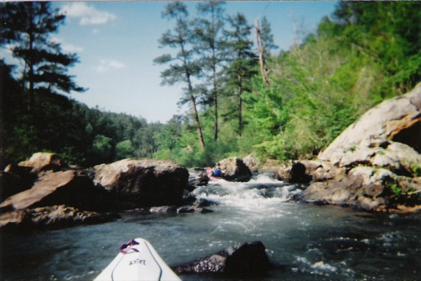
The lead in to the big stuff
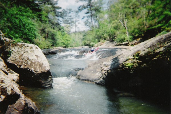
view from near the top of the biggest rapid. The picture is deceiving, but this is impressive for Central Alabama.
In the boulder garden.
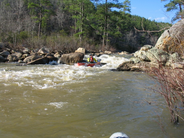
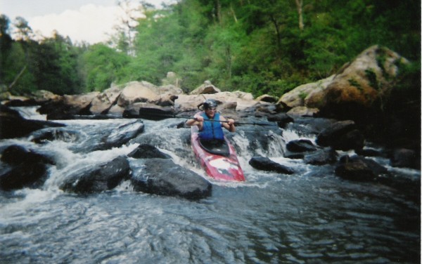
The final drop on Socapatoy, Attitude.
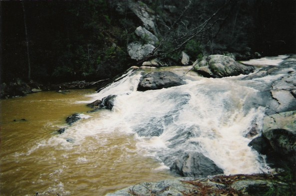
At higher water. photo courtesy Jeremy Addison
Trip Reports
Socapatoy Creek
March 1, 2005
Written by Dave Curry
According to Mark, Socapatoy has about a mile of whitewater in the middle of a 4 mile run. The creek was running swiftly and the flow seemed adequate so we jumped on and headed into the unknown. Sure enough, a little over a mile into the run, we began to encounter Class I-II rapids. Just like Swamp, the rocks changed from sandstone to granite, with some huge boulders in the stream. After a couple of good Class III slides, we came around a bend to view a distinct horizon line and some big boulders almost completely blocking the stream. I skirted a big rock, caught an eddy on river right, and climbed out of my boat to get a good look at what was downstream. What I saw made me glad I was paddling my “Big Red Security Blanket,” the Whitesell. The rapid started with a big curving slide into a generous pool; below that was a giant boulder garden that seemed to go on forever. After a brief discussion on the entry to the slide, Mark readied the camera and I took the plunge. The slide was actually easier than it looked, and I remembered to pull my elbows in as I rocketed past the boulder at the bottom. I climbed out and got some pictures of Mark’s run. The boulder garden turned out to be a fairly easy eddy-hop with a bit of “bump-and-scrape” along the way. More stream-flow would have made it a bit easier. After a few more shoals and some flat water, we were at the confluence with Hatchet creek and the final mile of swift moving flat water.
September 21, 2009
Written by John Owen
After spending countless days on the Tallapoosa Eric Olds & I were up for something a little less familiar. Eric had been down Socapatoy before at normal levels & this was my first time. It had been raining like crazy & we knew we were in for some fun.
Normally Socapatoy is a pretty boring ride leaving you anxiously paddling towards the Devil’s Canyon stretch, which is over all too soon. When we pulled up to the put-in bridge (after bottoming out in my little Dodge Neon & smashing the front end up), we knew we were in for a ride. Hatchet Creek was showing 3,750cfs on the gauge & Socapatoy itself looked to be at least 1,000cfs. The bridge was washed out. Only the first third of the wooden surface remained. The water was 1” below the bottom of the heavy steel beams still spanning the swollen creek.
With more than a bit of apprehension, we finally slid off the remains of the bridge & into the orange/brown water. About ½ mile downstream we found the first ½ of the missing bridge washed up on a large pile right in the middle of the creek. Around the first corner there were many trees in play, but none completely blocking the way. In this normally boring & never ending stretch there were lots of good reactionary waves & a few nasty holes. While it normally takes an hour plus of hard paddling to reach Devil’s Canyon, we were there in just a few quick minutes.
I’d read on the AlabamaWhitewater guide that Socapatoy had Class IV potential at high water. It was anything but a disappointment. We eddied out left well above the horizon line, knowing very well that once you start the decent, Its On Like Donkey Kong. After a difficult scout along the left bank we determined that by keeping far left we could slightly skirt the truly massive keeper hole that went 2/3 the way across the swollen creek. This would not be a fun one to be in.
After a hairy fairy, we made our way to the river right bank & scouted the normally easy slide that is the Frozen Rope. The Frozen Rope was completely washed out. Below it was a nasty hole that started 20’ from the river right bank & seemed to release the majority of its water all the way on river left & had serious beatdown potential. It was similar to a classic pipeline wave funneling all the water towards the left side, with a shallow rock ledge supporting it the whole way.
We finally determined the best line (besides walking, which would also be very difficult) to be the far river right. While this is normally dry, on this day the 10’ ledge was flowing very well. Eric lead out & punched his way through & on down, getting only mildly surfed at the bottom. I followed right behind & got slightly off to the left after the first slight drop. I managed to get up close & personal with the nice big eddy circulating right under the massively undercut boulder. I managed to get pointed downstream again & had to paddle up, out of the eddy hole & over the pillow between me the 10’ ledge. At this point I could only hope that Eric Olds Man was doing better than I down below. I came over the edge, not sure what to expect below. After a pretty clean drop I found myself in a small hole, only feet away from feeding into the long ledge wave/hole we so wanted to avoid. I was able to surf safely into the eddy.
From there, was a great, but very pushy boulder garden. It kind of reminded me of the Minefields on S. Sauty at higher levels, but brown. Around the next bend is Hatchet Creek & the takeout @ the Hwy 231 bridge.
All-in-all, it was a fun trip! I’ve been back a few times since, but always at more reasonable levels. At the lower levels the Devil’s Canyon stretch is fun, but it’s a long paddle up to it. I’d be anxious to hit it again at higher levels, preferably with a larger crew. Let me finish with a word of caution. Paddling anything in flood stage is dangerous. The walls of Devil’s Canyon are steep & there’s really no place where you can setup safety rope. You’re either in the swift current, or you’re too far up the tree covered cliff walls to be able to assist.